|
Home Page
The whole river
The source to the Cabrach
The Cabrach
Glass
Glass to Huntly
Huntly to Rothiemay
Rothiemay to Bridge-of-Marnoch
Bridge-of-Marnoch to Turriff
Turriff to the Sea
Some websites
|
|
This website gives some directions for following the Deveron from source-to-sea.But there's no point in taking the
adventure out of it by giving complete directions and photos of all the interesting things you'll see.
It isn't a proper waymarked trail like the 'West Highland Way'.....some places there are well-manicured paths for the fishing
...for most of the way there is some sort of path...but there are boggy bits
and barbed-wire fences and occasional tributary burns that you need to jump across.
For most of the walk, it 's not easy to get lost: if you walk downstream you will eventually come to a bridge and a road.
The only place that i would really reccommend a map, is the section between the source and the Cabrach, as it's fairly wild country.
And there are hardly any shops or cafés near the river.
But it's a great walk..i recommend it!!! JW
All the bridges....there are 29 bridges that cross the river, plus a few fords
If you don't want to Walk the length of the deveron in one go, you can do it in instalments from bridge-to-bridge,
returning to where you started along the opposite bank.
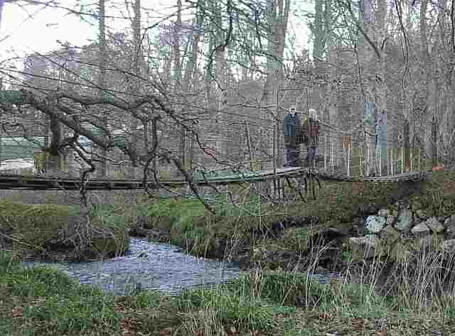
Some of the bridges are maintained by the farm people at their own expense....so don't be surprised if they don't
like you jumping on the suspension bridges to make them wobble.
The highest bridge is at Powneed. Upstream from here there are plenty of places where you can cross on stones. Map reference NJ 391 255
Big logs across the burn at 384 262 Not recommended
Road bridge at the Upper Cabrach church 385 267
The bridge at 382 279 fell down 40years ago, but it's still marked on an OS map that claims "revised 2007"
Road bridge at Kingsford 379288
Footbridge at the Grouse Inn 380 305
Bridge at Dalriach near where the Blackwater enters the Deveron 380 307
Road bridge where the A941 Cabrach Road crosses the Blackwater 378 308
Road bridge near Lesmurdie 387 315
Footbridge and ford at Lynebain 412 350
The bridge that's marked on the map at Walla Kirk 426 372 has fallen down.
Road bridge at Edinglassie 424 386
Footbridge at Invermarkie 427 392
Footbridge at blairmore 436 396
Bridge at Aswanley 439 396
Ford where jeeps from Aswanley House cross the river. 447 398 Only recommended in the summer
Road bridge 'the red brig' where the main Huntly-to-Dufftown road croses the river 487 406
Footbridge at InschTammack 498 422
Road bridge where the A96 Huntly-to-Inverness road crosses 515 407
Road bridge where the old Portsoy road crosses 517 408
The Huntly castle bridge 532 408
Slippery mossy stepping-stones at 537 411 Not recommended
Railway viaduct near Rothiemay. Not Recommended. 534 458
Old pontoons for fishing. Not recommended. 534 459
The suspension bridge at 534 471 has been demolished, but still shown on some maps
Bridge of Isla. Crosses the Isla half a mile from where the Isla meets the Deveron. 530 468
Road bridge in Rothiemay village 547 481
Footbridge at Mayen 583 484
Road bridge at Bridge of Marnoch, where the Huntly-to-Banff road crosses 604 495
Road bridge on the west edge of Turriff B9025 road 714 503
Pipeline with a substantial access-walkway near Eden 690 570
Bridge of Alvah 680 610
Bridge of Banff 694 638
Any comments or stories or photos about your walk along the deveron?.....
Or found a mistake in the info on this website??
please send your information to:- editor AT walking-the-deveron DOT freewebspace DOT Com
Deveron Arts in Huntly, commissioned the walk and the songbook etc.
Click HERE to visit their website
|